Sat in Green River in Utah we decided that to add a side trip to the Rocky Mountains National Park in Colorado or to the Badlands and Black Hills of South Dakota would be a step too far so for now Rocky Raccoon will have to wait. We drove north through Salt Lake City heading for Yellowstone National Park. GoogleMaps reckons that the trip from Green River to Jackson Hole can easily be driven in a day, but GoogleMaps does not have to stop for a coffee or giant barrel of soda and afterwards for a piss call and it doesn’t need to stop for lunch or to sleep. And GoogleMaps definitely does not make unplanned stops to browse an Outlet Mall on the edge of towns, although as far as these malls go the Tanger Outlet Centre near Salt Lake City is pretty nice, set in amongst the ski resort that hosted the Winter Olympics in 2002.

The trip to Jackson involved driving north through deserted towns and villages of Wyoming, many of them resembling the sort of Wild West towns seen on TV – wooden shop fronts and a wagon wheel in the car park. Jackson Hole itself is so much of a Wild West town that it goes overboard a bit and feels a little bit kitsch, probably something to do with the elk horn arches in the town square. Nevertheless it is a beautiful resort town surrounded by ski slopes that still had a fair dusting of snow when we arrived. Also, every town along the way seemed to have a fireworks shop or factory prominently placed within it. Is one of the major incomes of Wyoming revenue from fireworks sale and export?

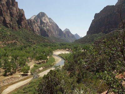
Grand Teton National Park lies just south of Yellowstone, in fact the entrance fee to the parks(if you don’t have an annual pass!) includes admission to both parks. Grand Teton National Park is a long thin stretch of land that is bordered by the Teton range on the Western side and the Antelope Flats on the east. The Teton range includes 12 peaks that are over 12,000 ft high with the 13,770ft Grand Teton towering over them all. In between the mountains and the flats are alpine forests and crystal clear lakes. And bears.

Both Grand Teton and Yellowstone have a large population of Grizzly and Black bears and every year there are scores of incidents involving bear vs. human interactions, and most often the human comes off second best. The park rangers recommend hikers to carry Bear Spray with them, a pepper spray mix that has been proven as more successful than a hand gun in warding off a bear. They also suggest that you clap your hands and sing whilst hiking, in order to give the bear time to retreat, because they don’t really want a confrontation any more than you do. I am not sure if this was not just a big joke as we set out on our first trek chanting “Hey Bear, Hey Yogi (#clapping)”.

There are over 200 miles of hiking trails in Grand Teton although some are impassable during the winter, and at the end of May it still felt like winter. We walked the very scenic Taggart Lake loop, which passes through the forest up to the lake, in which there are mirror views of the mountain range, before circling part of the lake and returning down to the trailhead. We also took the popular Hidden Falls and Inspiration Point trek which follows the northern shore of Jenny Lake before climbing into the hills to the hidden falls, which were surprisingly pretty. A little further on the trail rises above the tree line and up to Inspiration Point, which, not quite so surprisingly, has some nice views. On the way back we spotted a bald eagle in one of the trees above the trail, keeping an eye out over the lake for lunch no doubt. A more leisurely stroll is the flat trail that heads out from the marina at Colter Bay and around a small peninsular with views both back into the bay and out across the lake to the mountains.

From Colter Bay it is barely a one hour drive north out of Grand Teton past Flagg Ranch to the southern entrance to Yellowstone National Park. Yellowstone was the first National Park in the U.S.A and was created to protect the parks unique (in the US at least) natural geography – the geothermal areas, the Yellowstone Grand Canyon, the Lake and the fossil forests. In addition the park also contains over half the worlds geysers and the largest concentration of wildlife in the Lower 48. Then there are the beautiful lakes, rivers, waterfalls, forests and mountains. So, having said all that it was obvious that we would be slightly disappointed, I mean, where in the world could live up to such a litany of hype? Hiking trails were hard to find despite the claim of there being over 1200 miles of trails. We arrived in Yellowstone on the first of June but some roads were still closed under about 8 feet of snow and therefore many walking trails were also closed. There is also the same concern about bear encounters as in Grand Teton and therefore we limited ourselves to the shorter, less demanding boardwalk trails around the main sights – Yellowstone Lake, Yellowstone Grand Canyon, Tower Falls, Mammoth hot springs terraces, Norris Geyser basin, the Fountain Paint Pot trail and of course the Old Faithful geyser. And we still saw 6 bears in 24 hours, without even trying too! We also spotted moose and bison by the dozen but could not track down any Wolves, the parks other major predator. Old Faithful was impressive to see but sharing the experience with about 300 people sat on benches awaiting the eruption as slightly different to driving up to Geysir in Iceland (from where all other spouters get their name, albeit with a different spelling) and waiting for Strommur to erupt, most often for your eyes only.

One great aspect about the U.S. National Park service, in addition to all the other points I have already made, is their attitude to gift shops, cafes, restaurants and other services. Services of this manner can be found in most national parks, some more limited than others obviously, but they are always reasonably priced, no ’premium location’ pricing, and they are always set up to feel like a service, not a money making enterprise or a destination in themselves. The NPS seems to take pains to ensure that the emphasis is on the park itself at all times. Which is a good thing. By the time we left Yellowstone the Flagg Ranch primitive campsites, between the parks, had opened giving the opportunity to camp in the wilderness by the Snake River. Driving in we did spot a Grizzly wandering by the side of the road, plenty of cars pulled up and jumped out toting their cameras, us included. We all forgot our Bear Aware rules in order to get the best photo. As this was not even a couple of miles from our campsite we decided to sleep in the car rather than pitch our tent!

Heading south back to Salt Lake City we decided to take a different route, crossing over into the corner of Idaho before re-entering Utah. It took even longer, crossing a couple of mountain passes and having to slow down to go through every town, just in case the three men and a dog decided to run out into the street.
Salt Lake City is the home of the Mormon church and the State capital. It has a very compact and clean centre with most of the interesting buildings crowded around Temple Square. Situated here are the Head Church and the administrative buildings as well as the Tabernacle recital hall and the small Beehive house. The city seems unexpectedly small and low-key but a different side of the city is revealed on the journey out to the Great Salt Lake itself as we passed horrific roadworks, a few drunks lying prostate on the sidewalks and some really dodogy looking characters roaming around. The total opposite of what Mark Twain noticed in 1872 (taken from our old Lonely Planet), he probably never left the pretty little centre, or rather that was all there was in those days: “Next day we stolled about everywhere, through the broad, straight, level streets, and enjoyed the pleasant strangeness of a city of fifteen thousand inhabitants with no loafers perceptible in it; and no visible drunkards or noisy people.” The Great Salt Lake is beautiful at sunset, with the saline waters turning the reflections all kinds of pink and orange hues. People do stay there all day to sunbathe and wade in the waters but personally I would have been put off by the vile stench of rotting fish that permeated every pore. I could put up with it for a short stroll though.

The road west through to Nevada passes through a desolate stretch of nothingness, not a streetlight or soul for a hundred miles until the Nevada border where the garish town of Wendover loudly advertises its casinos and brothels in bright lights. Driving across Nevada all that is encountered are prisons and casinos. Does Nevada have any other industry other than gambling and penitentiaries? Either way it is a depressing place. Sure, Las Vegas is good for a laugh but that is because it has a bit of personality, something that places like Wendover and Reno are sorely lacking. When you run out of petrol just 200 yards from the first pump encountered for 100 miles though you do feel some sort of divine intervention. When a bunch of giant Hispanic guys emerge from the darkness to help push that last 200 yards it feels even better, we both felt ashamed that our first thought was that we were about to be mugged. We were happy to cross Nevada in one long drive and head straight for Lake Tahoe on the border with California. We arrived in Tahoe to glorious weather, the sun shining on the turquoise lake and snowy mountains behind. It was also the day of the annual Tahoe cycling race which was great to see as well. Unfortunately we took no photographs on that day at all and the next day we awoke to overcast skies and some heavy rain and snow storms.
The trip to Jackson involved driving north through deserted towns and villages of Wyoming, many of them resembling the sort of Wild West towns seen on TV – wooden shop fronts and a wagon wheel in the car park. Jackson Hole itself is so much of a Wild West town that it goes overboard a bit and feels a little bit kitsch, probably something to do with the elk horn arches in the town square. Nevertheless it is a beautiful resort town surrounded by ski slopes that still had a fair dusting of snow when we arrived. Also, every town along the way seemed to have a fireworks shop or factory prominently placed within it. Is one of the major incomes of Wyoming revenue from fireworks sale and export?
Grand Teton National Park lies just south of Yellowstone, in fact the entrance fee to the parks(if you don’t have an annual pass!) includes admission to both parks. Grand Teton National Park is a long thin stretch of land that is bordered by the Teton range on the Western side and the Antelope Flats on the east. The Teton range includes 12 peaks that are over 12,000 ft high with the 13,770ft Grand Teton towering over them all. In between the mountains and the flats are alpine forests and crystal clear lakes. And bears.
Both Grand Teton and Yellowstone have a large population of Grizzly and Black bears and every year there are scores of incidents involving bear vs. human interactions, and most often the human comes off second best. The park rangers recommend hikers to carry Bear Spray with them, a pepper spray mix that has been proven as more successful than a hand gun in warding off a bear. They also suggest that you clap your hands and sing whilst hiking, in order to give the bear time to retreat, because they don’t really want a confrontation any more than you do. I am not sure if this was not just a big joke as we set out on our first trek chanting “Hey Bear, Hey Yogi (#clapping)”.
There are over 200 miles of hiking trails in Grand Teton although some are impassable during the winter, and at the end of May it still felt like winter. We walked the very scenic Taggart Lake loop, which passes through the forest up to the lake, in which there are mirror views of the mountain range, before circling part of the lake and returning down to the trailhead. We also took the popular Hidden Falls and Inspiration Point trek which follows the northern shore of Jenny Lake before climbing into the hills to the hidden falls, which were surprisingly pretty. A little further on the trail rises above the tree line and up to Inspiration Point, which, not quite so surprisingly, has some nice views. On the way back we spotted a bald eagle in one of the trees above the trail, keeping an eye out over the lake for lunch no doubt. A more leisurely stroll is the flat trail that heads out from the marina at Colter Bay and around a small peninsular with views both back into the bay and out across the lake to the mountains.
From Colter Bay it is barely a one hour drive north out of Grand Teton past Flagg Ranch to the southern entrance to Yellowstone National Park. Yellowstone was the first National Park in the U.S.A and was created to protect the parks unique (in the US at least) natural geography – the geothermal areas, the Yellowstone Grand Canyon, the Lake and the fossil forests. In addition the park also contains over half the worlds geysers and the largest concentration of wildlife in the Lower 48. Then there are the beautiful lakes, rivers, waterfalls, forests and mountains. So, having said all that it was obvious that we would be slightly disappointed, I mean, where in the world could live up to such a litany of hype? Hiking trails were hard to find despite the claim of there being over 1200 miles of trails. We arrived in Yellowstone on the first of June but some roads were still closed under about 8 feet of snow and therefore many walking trails were also closed. There is also the same concern about bear encounters as in Grand Teton and therefore we limited ourselves to the shorter, less demanding boardwalk trails around the main sights – Yellowstone Lake, Yellowstone Grand Canyon, Tower Falls, Mammoth hot springs terraces, Norris Geyser basin, the Fountain Paint Pot trail and of course the Old Faithful geyser. And we still saw 6 bears in 24 hours, without even trying too! We also spotted moose and bison by the dozen but could not track down any Wolves, the parks other major predator. Old Faithful was impressive to see but sharing the experience with about 300 people sat on benches awaiting the eruption as slightly different to driving up to Geysir in Iceland (from where all other spouters get their name, albeit with a different spelling) and waiting for Strommur to erupt, most often for your eyes only.
One great aspect about the U.S. National Park service, in addition to all the other points I have already made, is their attitude to gift shops, cafes, restaurants and other services. Services of this manner can be found in most national parks, some more limited than others obviously, but they are always reasonably priced, no ’premium location’ pricing, and they are always set up to feel like a service, not a money making enterprise or a destination in themselves. The NPS seems to take pains to ensure that the emphasis is on the park itself at all times. Which is a good thing. By the time we left Yellowstone the Flagg Ranch primitive campsites, between the parks, had opened giving the opportunity to camp in the wilderness by the Snake River. Driving in we did spot a Grizzly wandering by the side of the road, plenty of cars pulled up and jumped out toting their cameras, us included. We all forgot our Bear Aware rules in order to get the best photo. As this was not even a couple of miles from our campsite we decided to sleep in the car rather than pitch our tent!
Heading south back to Salt Lake City we decided to take a different route, crossing over into the corner of Idaho before re-entering Utah. It took even longer, crossing a couple of mountain passes and having to slow down to go through every town, just in case the three men and a dog decided to run out into the street.
Salt Lake City is the home of the Mormon church and the State capital. It has a very compact and clean centre with most of the interesting buildings crowded around Temple Square. Situated here are the Head Church and the administrative buildings as well as the Tabernacle recital hall and the small Beehive house. The city seems unexpectedly small and low-key but a different side of the city is revealed on the journey out to the Great Salt Lake itself as we passed horrific roadworks, a few drunks lying prostate on the sidewalks and some really dodogy looking characters roaming around. The total opposite of what Mark Twain noticed in 1872 (taken from our old Lonely Planet), he probably never left the pretty little centre, or rather that was all there was in those days: “Next day we stolled about everywhere, through the broad, straight, level streets, and enjoyed the pleasant strangeness of a city of fifteen thousand inhabitants with no loafers perceptible in it; and no visible drunkards or noisy people.” The Great Salt Lake is beautiful at sunset, with the saline waters turning the reflections all kinds of pink and orange hues. People do stay there all day to sunbathe and wade in the waters but personally I would have been put off by the vile stench of rotting fish that permeated every pore. I could put up with it for a short stroll though.
The road west through to Nevada passes through a desolate stretch of nothingness, not a streetlight or soul for a hundred miles until the Nevada border where the garish town of Wendover loudly advertises its casinos and brothels in bright lights. Driving across Nevada all that is encountered are prisons and casinos. Does Nevada have any other industry other than gambling and penitentiaries? Either way it is a depressing place. Sure, Las Vegas is good for a laugh but that is because it has a bit of personality, something that places like Wendover and Reno are sorely lacking. When you run out of petrol just 200 yards from the first pump encountered for 100 miles though you do feel some sort of divine intervention. When a bunch of giant Hispanic guys emerge from the darkness to help push that last 200 yards it feels even better, we both felt ashamed that our first thought was that we were about to be mugged. We were happy to cross Nevada in one long drive and head straight for Lake Tahoe on the border with California. We arrived in Tahoe to glorious weather, the sun shining on the turquoise lake and snowy mountains behind. It was also the day of the annual Tahoe cycling race which was great to see as well. Unfortunately we took no photographs on that day at all and the next day we awoke to overcast skies and some heavy rain and snow storms.

It is a deceptively long drive from Tahoe to Yosemite, climbing up and down through the Sierra Nevada mountains. With over 4 million visitors every year it is obviously a popular park but it has the beauty to justify that popularity. It does make a visit slightly over-whelming, I am not used to having to join a long queue to climb a trail or catch a glimpse from a viewpoint, but there is a reason that famous photographer Ansel Adams spent so much time at Yosemite. Ansel Adams was a great photographer and chronicler of the U.S National parks at a time when it took considerably more time and effort and expense than today, he had to drive a whole truck full of gear just to take a few photos. There was an article about his visits to the High Sierras (particularly Kings Canyon and Sequoi national parks) in a recent issue of National Geographic and he has been repaid for his dedication to Yosemite with the Ansel Adams gallery at the Visitors Centre. For visitors looking for a quieter experience the rangers recommend visiting one of the areas of the park outside Yosemite Valley itself, but unfortunately during our visit these roads were all still closed! In any case the sights that make Yosemite popular are all in the Valley, from El Capitan - the worlds largest granite monolith with climbers resembling ants as they scale its walls – to Half Dome, the famous peak that looms over the whole of the valley.

We would have loved to have made the famous Half Dome trek, an 18 hour hike to the summit, but unfortunately this can only be made with a permit, which has to applied for through a lottery months in advance. Instead we hiked up the Mist Trail, a 5 mile climb past Vernal and Nevada Falls. Not expecting much at all we were pleased to find some amazing views along the way as well as it being a really great trail. With no space available in any campground we drove up out of Yosemite Valley, stopped for one last photo at the Tunnel viewpoint, the famous view of El Capitan, Bridalveil Falls and Half Dome; and left.

One reason I was not too disappointed to leave Yosemite is due to the black bears there. Unlike the bears in Yellowstone, those in Yosemite, Kings Canyon and Seqouia national parks tend to pose less of a threat to humans but are remarkably adept at breaking into cars, tents and other places to get at food. Every day there are fresh reports of cars damaged overnight by bears and it is actually illegal to leave food in your car overnight within the park. Obviously inside the tent would be an even stupider place to leave it so there are ‘bear-proof’ lockers around to store food in. Still, I wouldn’t want to wake up in the morning and find out the hard way that I had left a packet of crisps in the glove box.

Kings Canyon and Sequoia national parks sit side by side to the south of Yosemite and involve a further long, meandering drive around the mountains and through forgettable Fresno to access them. Whilst not quite as scenic as Yosemite the pay-off is that they are relatively quiet, with perhaps 10% of the visitors. The two highlights of the parks are the canyon itself and the stunning views thereof as you descend to its floor and the forests of giant sequoia trees, including the worlds largest tree (by trunk volume) the General Sherman tree. In Kings Canyon stands the General Grant tree and the two trees are connected by the ‘Generals Highway’. The Grant tree is not so massive but is known as the nations Christmas tree. Impressive and enjoyable was the trek up to the Cedar Grove overlook with view of the Cedar Grove side of Kings Canyon on the way up and the Lewis Creek side on the way down. Driving back up out of the canyon we stopped several times to photograph the colourful Parry Nolinas clinging to the side. Over in Sequoia national park we walked one of the trails through the Giants Forest, with trees that are close to 300ft tall, 40ft in diameter and 3000 years old but abandoned it after getting lost and found ourselves back on the main road in a crowd of people just as a black bear and her cub had wandered out over the other side, lucky we got lost! There are some great free campsites in the parks, and to spend a night under the stars with a campfire roaring was a great experience. Bearing in mind the temperature dropped to around freezing overnight the fire was a necessity rather than a luxury!

During our first few days in California we did notice a slight change in the behaviour of people compared to those we met in Utah, Wyoming and during our trip from New Orleans to Las Vegas. Whilst on the whole still very considerate and careful the standard of driving does not seem quite as high here, we have noticed more instances of speeding and use of mobile phones whilst driving and we almost got broadsided by a negligent truck driver whilst joining a highway. Also the standard of customer service does not quite seem so important here either – at the Visitor Centre in Yosemite we walked out with half our questions unanswered due to the rangers attitude. In every other park up to that point (with the exception of one incompetent guy at Bryce Canyon) we had received precise, in-depth advice with a lot of personal experience thrown in for good measure. Here we received answers to our questions which felt more like premeditated ways to answer without taking any responsibility.

We have also witnessed a couple of dodgy situations since arriving in California. On arriving at the entrance to Yosemite late in the evening we came across a parking lot which appeared to be attached to some sort of camp or lodge. There were a dozen vehicles parked outside, all seemingly packed with camping gear, food and other equipment. However as we slowed down to check it out we realised something was slightly amiss. Three of the cars had their boots wide open despite not a soul being around at all and one of the cars had two of the windows smashed. We started to discuss whether these were the actions of humans or bears when we were alerted by the sound of an engine starting up. As we drove away from this eerie scene we were followed by a guy driving a school bus. We arrived at Kings Canyon at a similar time late at night. Here we met a couple of Hispanic guys towing a car down a narrow mountain road at midnight. When we tried to negotiate passing them on a tight bend one of them came to speak to us but we found he could not speak English at all. As soon as we were passed they hurried away as best they could with their burden. Further on we came to the campsite we planned to stay in but found it to be deserted other than a couple of huts on a hillside that best resembled some sort of concentration camp buildings. Again we quickly left! Having said that, it is just our perception that California is not as welcoming as the other States we have visited, we are yet to really suffer any negative experiences. Oh, other than the fact that petrol is over $4 a gallon in the Californian interior!

From one extreme to another, just a days drive down out of the Sierra mountains and through the nondescript town of Bakersfield leads to the hottest place in the U.S.A – Death Valley. During a visit to Death Valley all that anyone seems to talk about is the temperature, how it increased 30°F during one 13 mile stretch and dropped 26°F during another. Everyone imagines Death Valley to be a desolate landscape, devoid of any life, and that is exactly how it is. However what most people don’t expect is that this environment can still be starkly beautiful. The amazing colours around aptly named Artist Palette Drive, the strange buckled salt flats of Devils Gold Course and the views from Zabriskie Point and Dantes View were all far in excess of my expectations. Perhaps most impressive was walking out over the salt lake of Badwater Basin, the lowest point in the U.S.A at 280ft below sea level. The salt was blinding and with the thermometer nosing 116°F in the shade just walking across it was debilitating. So what is the most ideal place to visit after leaving Death Valley? According to whichever divine power placed them there, hot springs. Yes, we drove out of Death Valley to camp just up the road at Tecopa Hot Springs, cleansing ourselves of the dust in the steaming hot baths.

Heading south we drove straight through the Mojave desert, stopping in the ghost town of Amboy on the old Route 66 and visiting the volcanic crater on the edge of town. Apparently there is an airplane graveyard somewhere in the Mojave desert but we couldn’t find it, all the more reason to return to New Mexico at some point and see the planes at White Sands. What we did see were amazing celestial displays of the sky at night. Out here in the desert there is very little light pollution and virtually no cloud or haze giving perfect visibility for star-gazing.

The Mojave desert does have a lot of Joshua trees growing in it though and the next day we visited the Joshua Tree National Park. Many of you would recognise the tree from the front cover of the half-decent album that Irish band made before they totally sold out and the singer turned into a knobhead. For those that don’t know what they look like they are something like a cross between a cactus and a palm tree, giant cactus trees with furry trunks and yellow flowers. The national park also contains some amazing rock formations providing the perfect backdrop for the forests of Joshua trees. There are some short trails in the park and a lot of amazing views and all-in-all it is a very interesting place to visit, especially at the start of a trip through the amazing national parks of the Southwest USA. Unfortunately for us Joshua Tree was our last park before we hit the Pacific coast.

Our last stop before San Diego was the desert resort town of Palm Springs, renowned for being an oasis of peace and quiet for weekending celebs. However, rather than wander past Anthony Hopkins preferred laundromat or where Harrison Ford buys his groceries we were more interested in the giant, even by American standards, wind farm dominating the valley into town. Personally I love wind turbines, I think a wind farm enhances rather than blights a landscape with their sleek, futuristic design and the way they all spin symmetrically so I was amazed to find them in such numbers here. The warning to motorists that ‘Gusty Winds May Exist’ gives away the reason why this spot was chosen!