Entering Utah seemed almost like proof of a higher power. I am not referring to the shiny churches in each town serving the Mormon population in their homeland but rather the divine intervention of placing such incredible sights as the parks of the Colorado Plateau so close to Las Vegas. A few days amongst the red rocks of Southern Utah are enough to cleanse any dishevelled body and soul from the over-indulgences enjoyed in the Sin City.
A few weeks before we had picked up an ‘America the Beautiful – National Parks and Federal Recreation Areas Pass’ which is a long-winded name for a Annual Pass that allows the bearer, plus a car and up to four people, access to all National Parks and federal areas for the princely sum of $80. That is a steal in any currency, especially when each individual park can charge up to $25 for a single visit. In addition we managed to extend our car rental from Alamo and arrange and upgragde after receiving incredible customer service at their Las Vegas branch. We did this after cancelling a Dollar reservation at the last minute due to a ridiculously high number of hidden charges and fees.

Zion National Park was the first stop we made in Utah. One of the most popular parks in the U.S. the traffic used to be so congested that they now have a very efficient and handy shuttle system to move visitors around the different sites. There are huge, towering red and pink rocks looming over the walls of the Zion canyon and the canyon floor is irrigated by the Virgin River, bringing some green cover to the semi-desert landscape. There are several different trailheads along the canyon from where treks go off into various directions, some of them being long trips lasting several days, no mean feat when you consider the scarcity of drinkable water. Probably the most famous trek is the Narrows, which involves a lot of ‘river running’ during the trek, this is one of the most popular activities at all parks we have visited – trekking through rivers in waterproof river-running boots. At all visitors centres we had to stress we were not looking for river treks, we always received a look of sympathy in return, as if to say we don’t know what we are missing!
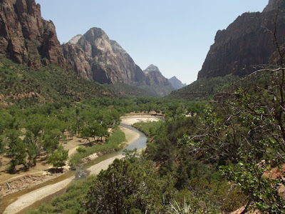
We hiked the short trek to the Emerald Pools and the Riverwalk which leads to the start of the Narrows trek. The temperature was in the 90’s and the air way so dry it scorched the lungs so this was enough for our first park. We planned to exit the park via the Mt Carmel highway which climbs up over the canyon with further trekking opportunities and some panoramic viewpoints along the way. Unfortunately, just as we had snaked half-way up the road a fleet of about 15 emergency vehicles zoomed past, sirens blazing and the road was closed. A car had caught fire in the narrow tunnel that leads to the mountain road. Of course we were disappointed to have to turn around and go the long, boring way round to Bryce Canyon but at the same time our thoughts turned to those stuck in the tunnel, in the flaming car and those trapped behind.

We drove on towards Bryce Canyon, camping overnight in a small, friendly campsite in the town of Panguitch. Bryce Canyon National Park is famous for the hoodoos – the jutting rock pillars in the same pinks and reds that rise up from the base of the canyon. Apparently hoodoos are found in many places around the world. The rock formations of Cappadocia in Turkey are the result of similar geological actions. Actually more of an ‘amphitheatre’ than a canyon the views from the rim at Bryce over the hoodoos are stunning. Set on the Paria river, the canyon got its name after Ebeneezer Bryce arrived and set up his ranch there, calling it “a hell of a place to lose a cow”.

The trails that head down amongst the hoodoos from the rim lead to amazing views with the Queens Garden/Navajo Loop combination being dubbed ‘the world’s greatest 3 mile hike’. This may just be a little bit of hyperbole but I am not in a position to disagree. We extended it to include the Peekaboo Loop further south to make it an incredible five mile figure-of-8 trek with a really steep climb up the Wall Street canyon to finish with. I know that Lenka and Pavel would have loved to hike that trail. There are viewpoints all along the rim, connected by a walking trail for the full length. Some of the best views were at Sunset Point, Bryce Point further south and Fairyland Point at the northern entrance to the park.

Bryce Canyon and Capitol Reef National Parks are connected by the Grand Staircase – Escalante National Monument which dominates southern Utah. Most of the hikes here are much longer, requiring several days so we just admired the scenery as we drove along the typical roads hugging the sides of mountains on the way down to the floor and back up again. The views changed every couple of miles and the rocks changed colour with the views – shifting from vermillion to bright white and back again. We stopped in at the park headquarters in Escalante before crossing a couple of 9000ft passes on the way to Capitol Reef, finding a camping spot with true million-dollar views. Within some lands controlled by the Bureau of Land Management free camping is allowed in spots where somebody has camped before. This is known as dispersed camping and was encouraged by every park ranger we met. It was strange being encouraged to wild camp away from any facilities but we didn’t need telling twice! It is not always the case though so it pays to keep an eye out for the ‘No camping’ signs just in case.

Capitol Reef is one of the lesser known and certainly less visited national parks in Utah but it is no less impressive. Along with Bryce Canyon it may have been my favourite. There were many people at Zion lamenting that they had no time to visit the other parks, they just came to see Zion, and this is a great shame. Capitol Reef is the result of the 65 million year old Waterpocket Fold which caused the earth to buckle. This caused the earth to reveal yet more examples of the beauty of the Colorado Plateau.

Making up for just driving through Grand Staircase we hiked three treks at Capitol Reef. Probably the most popular trek in the park is the trail up to Hickman Bridge, so popular however that there was a massive school group there when we arrived. We didn’t stick around for long. We made a second trek along the base of the Capitol Gorge which passed some old water ‘tanks’ and a Pioneer Register. This seemed to me just a wall of 19th Century graffiti, albeit mostly in a more refined hand than the illiterate tagging of modern ‘artists’. I wonder if in a hundred years time people will trek to see examples of today’s graffiti? I must also admit that hiking within a canyon is not my favourite pastime; I find it as monotonous as walking on a beach. I much prefer to be distracted by awesome views whilst hiking along. As Monika said, I would rather be watching a Test match between Bangladesh and Zimbabwe than walking in the bottom of a canyon! With that in mind I was most impressed with the final trek we made at Capitol Reed – the Chimney Rock Loop Trail. This 7-mile trail leads up a rocky outcrop to viewpoints over the jagged reef itself before descending down to the river bed and back to the trailhead. Along with the trek at Bryce Canyon these two were the best walks we took in Utah.

From Capitol Reef we drove through the intimidating sprawl of the Glen Canyon Recreation Area. Lake Powell sits in the bottom of the canyon, created by the building of the Glen Canyon dam over a hundred miles away at the other end of the canyon. The highlight of Lake Powell for many people is to take their boat out from Bullfrog marina for a sail. Unfortunately we arrived at the same time as a massive dust storm so most of the boats remained moored for the weekend. For us the highlight was the views along the road as we snaked up, down and around the various walls of the canyon.

Within the Glen Canyon area is the Natural Bridges National Monument, which was Utah’s first protected area of land declared a National Monument in 1908. We arrived at this small park too late in the day to hike down to the bridges but made the loop drive that connects up the overlooks of the 3 main bridges in the park, named "Kachina," "Owachomo" and "Sipapu".

Halfway between Natural Bridges and Monument Valley the road descends very steeply, snaking down the edge of a cliff several hundred metres below. Atop this cliff is another primitive camping spot, this one with views over the entire of Monument Valley. Unfortunately the dust storm was getting worse and worse so the next day, rather than take a tour around Monument Valley and perhaps heading across into Colorado to the Mesa Verde ruins we made a beeline north to Moab.

Moab is one of the outdoor capitals of the U.S sitting right on the doorstep of Arches and Canyonlands National Parks. It is a nice enough place to spend a day and whilst we were there we caught the Moab Arts Festival as well. The area is also popular for climbers as well, especially within the Castle Valley. We arrived in Moab during Memorial Day weekend which meant the place was packed but we were able to camp with the climbers who were spending their holidays climbing Castleton Tower.

Probably the most famous park in Utah, no-one visits the parks here without making a trip to Arches National Park. Within the park boundaries is the greatest concentration of natural rock arches in the world. Apparently the difference between a natural rock arch and a natural bridge is due to the presence of a river under a natural bridge causing the rock erosion. In any case, Arches is very popular and unfortunately, unlike Bryce and Zion, they are yet to implement a shuttle system, which means a lot of time is spent queuing for parking spaces and edging around the giant RV’s taking up the whole road.
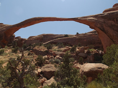
We made three treks at Arches. The 1st was to famous Delicate Arch, a nice trek up, brilliant views and an impressive arch, just a shame you have to share the experience with about 10,000 other people! The second trek we made was the Double-O Arch loop which passes the gravity defying Landscape Arch, off-limits to close inspection since a large piece fell off in 1991. Double-O arch itself is surprising because the double-O’s are one atop the other, I am sure most people expect them to be side-by side. This trek was probably the highlight of Arches for us as we then returned via the ‘Primitive Trail’ which gave us a chance to admire the scenery of the park away from the hordes of people. The last trek we made was the very short loop around the Windows arches and Turret Arch. Windows arches do sit side-by-side and look pretty impressive from further away, revealing the northern arch. Turret Arch itself was particularly beautiful shining in the late afternoon sun. Our final photo of Arches was of the famous Balancing Rock, which sits just beside the main road near the entrance to the park.

Canyonlands was the last of the Big 5 Parks circuit that we visited and probably the least visited overall despite one of the three entrances being so close to Moab. Visitors are probably put off by the long hikes and harsh conditions and with only one real viewpoint over the park from this point. We undertook just one trek at Canyonlands, the tough 11 mile Murphy Loop which started with a hair-raising descent down one of the sides of the canyon. Canyonlands really felt like the edge of the earth for us – a hot and dry place where nothing can thrive.

One thing that was most impressive for us in Utah is how accessible the parks are. Anyone can visit and there are special facilities for the elderly, disabled and the obese. As a result the cross-section of society you see at the parks is much more mixed than you would ever find in a similar place in Europe. Especially for the ‘seniors’ over here the quality of life seems far better than in Europe. Age does not seem to be a barrier here to physical activity at all. We saw a bus pull up next to a row of white-water rafts. We expected a bunch of buff young guys to emerge back-slapping their way on to the rafts but no, no-one on the bus was under 70 years of age. There also doesn’t seem to be any sort of class barrier as to who would visit the park, anyone would visit. It was also great to see so many families from immigrant communities visiting as well, not just the sizeable number of Hispanic families but tonnes of Indian families as well as groups from Japanese, Chinese and Korean communities. It was amazing to see although I did feel sorry for the skinny Indian husbands having to hoist their plump sari-clad wives up the steeper sections of the trails!
Zion National Park was the first stop we made in Utah. One of the most popular parks in the U.S. the traffic used to be so congested that they now have a very efficient and handy shuttle system to move visitors around the different sites. There are huge, towering red and pink rocks looming over the walls of the Zion canyon and the canyon floor is irrigated by the Virgin River, bringing some green cover to the semi-desert landscape. There are several different trailheads along the canyon from where treks go off into various directions, some of them being long trips lasting several days, no mean feat when you consider the scarcity of drinkable water. Probably the most famous trek is the Narrows, which involves a lot of ‘river running’ during the trek, this is one of the most popular activities at all parks we have visited – trekking through rivers in waterproof river-running boots. At all visitors centres we had to stress we were not looking for river treks, we always received a look of sympathy in return, as if to say we don’t know what we are missing!
We hiked the short trek to the Emerald Pools and the Riverwalk which leads to the start of the Narrows trek. The temperature was in the 90’s and the air way so dry it scorched the lungs so this was enough for our first park. We planned to exit the park via the Mt Carmel highway which climbs up over the canyon with further trekking opportunities and some panoramic viewpoints along the way. Unfortunately, just as we had snaked half-way up the road a fleet of about 15 emergency vehicles zoomed past, sirens blazing and the road was closed. A car had caught fire in the narrow tunnel that leads to the mountain road. Of course we were disappointed to have to turn around and go the long, boring way round to Bryce Canyon but at the same time our thoughts turned to those stuck in the tunnel, in the flaming car and those trapped behind.
We drove on towards Bryce Canyon, camping overnight in a small, friendly campsite in the town of Panguitch. Bryce Canyon National Park is famous for the hoodoos – the jutting rock pillars in the same pinks and reds that rise up from the base of the canyon. Apparently hoodoos are found in many places around the world. The rock formations of Cappadocia in Turkey are the result of similar geological actions. Actually more of an ‘amphitheatre’ than a canyon the views from the rim at Bryce over the hoodoos are stunning. Set on the Paria river, the canyon got its name after Ebeneezer Bryce arrived and set up his ranch there, calling it “a hell of a place to lose a cow”.
The trails that head down amongst the hoodoos from the rim lead to amazing views with the Queens Garden/Navajo Loop combination being dubbed ‘the world’s greatest 3 mile hike’. This may just be a little bit of hyperbole but I am not in a position to disagree. We extended it to include the Peekaboo Loop further south to make it an incredible five mile figure-of-8 trek with a really steep climb up the Wall Street canyon to finish with. I know that Lenka and Pavel would have loved to hike that trail. There are viewpoints all along the rim, connected by a walking trail for the full length. Some of the best views were at Sunset Point, Bryce Point further south and Fairyland Point at the northern entrance to the park.
Bryce Canyon and Capitol Reef National Parks are connected by the Grand Staircase – Escalante National Monument which dominates southern Utah. Most of the hikes here are much longer, requiring several days so we just admired the scenery as we drove along the typical roads hugging the sides of mountains on the way down to the floor and back up again. The views changed every couple of miles and the rocks changed colour with the views – shifting from vermillion to bright white and back again. We stopped in at the park headquarters in Escalante before crossing a couple of 9000ft passes on the way to Capitol Reef, finding a camping spot with true million-dollar views. Within some lands controlled by the Bureau of Land Management free camping is allowed in spots where somebody has camped before. This is known as dispersed camping and was encouraged by every park ranger we met. It was strange being encouraged to wild camp away from any facilities but we didn’t need telling twice! It is not always the case though so it pays to keep an eye out for the ‘No camping’ signs just in case.
Capitol Reef is one of the lesser known and certainly less visited national parks in Utah but it is no less impressive. Along with Bryce Canyon it may have been my favourite. There were many people at Zion lamenting that they had no time to visit the other parks, they just came to see Zion, and this is a great shame. Capitol Reef is the result of the 65 million year old Waterpocket Fold which caused the earth to buckle. This caused the earth to reveal yet more examples of the beauty of the Colorado Plateau.
Making up for just driving through Grand Staircase we hiked three treks at Capitol Reef. Probably the most popular trek in the park is the trail up to Hickman Bridge, so popular however that there was a massive school group there when we arrived. We didn’t stick around for long. We made a second trek along the base of the Capitol Gorge which passed some old water ‘tanks’ and a Pioneer Register. This seemed to me just a wall of 19th Century graffiti, albeit mostly in a more refined hand than the illiterate tagging of modern ‘artists’. I wonder if in a hundred years time people will trek to see examples of today’s graffiti? I must also admit that hiking within a canyon is not my favourite pastime; I find it as monotonous as walking on a beach. I much prefer to be distracted by awesome views whilst hiking along. As Monika said, I would rather be watching a Test match between Bangladesh and Zimbabwe than walking in the bottom of a canyon! With that in mind I was most impressed with the final trek we made at Capitol Reed – the Chimney Rock Loop Trail. This 7-mile trail leads up a rocky outcrop to viewpoints over the jagged reef itself before descending down to the river bed and back to the trailhead. Along with the trek at Bryce Canyon these two were the best walks we took in Utah.
From Capitol Reef we drove through the intimidating sprawl of the Glen Canyon Recreation Area. Lake Powell sits in the bottom of the canyon, created by the building of the Glen Canyon dam over a hundred miles away at the other end of the canyon. The highlight of Lake Powell for many people is to take their boat out from Bullfrog marina for a sail. Unfortunately we arrived at the same time as a massive dust storm so most of the boats remained moored for the weekend. For us the highlight was the views along the road as we snaked up, down and around the various walls of the canyon.
Within the Glen Canyon area is the Natural Bridges National Monument, which was Utah’s first protected area of land declared a National Monument in 1908. We arrived at this small park too late in the day to hike down to the bridges but made the loop drive that connects up the overlooks of the 3 main bridges in the park, named "Kachina," "Owachomo" and "Sipapu".
Halfway between Natural Bridges and Monument Valley the road descends very steeply, snaking down the edge of a cliff several hundred metres below. Atop this cliff is another primitive camping spot, this one with views over the entire of Monument Valley. Unfortunately the dust storm was getting worse and worse so the next day, rather than take a tour around Monument Valley and perhaps heading across into Colorado to the Mesa Verde ruins we made a beeline north to Moab.
Moab is one of the outdoor capitals of the U.S sitting right on the doorstep of Arches and Canyonlands National Parks. It is a nice enough place to spend a day and whilst we were there we caught the Moab Arts Festival as well. The area is also popular for climbers as well, especially within the Castle Valley. We arrived in Moab during Memorial Day weekend which meant the place was packed but we were able to camp with the climbers who were spending their holidays climbing Castleton Tower.
Probably the most famous park in Utah, no-one visits the parks here without making a trip to Arches National Park. Within the park boundaries is the greatest concentration of natural rock arches in the world. Apparently the difference between a natural rock arch and a natural bridge is due to the presence of a river under a natural bridge causing the rock erosion. In any case, Arches is very popular and unfortunately, unlike Bryce and Zion, they are yet to implement a shuttle system, which means a lot of time is spent queuing for parking spaces and edging around the giant RV’s taking up the whole road.
We made three treks at Arches. The 1st was to famous Delicate Arch, a nice trek up, brilliant views and an impressive arch, just a shame you have to share the experience with about 10,000 other people! The second trek we made was the Double-O Arch loop which passes the gravity defying Landscape Arch, off-limits to close inspection since a large piece fell off in 1991. Double-O arch itself is surprising because the double-O’s are one atop the other, I am sure most people expect them to be side-by side. This trek was probably the highlight of Arches for us as we then returned via the ‘Primitive Trail’ which gave us a chance to admire the scenery of the park away from the hordes of people. The last trek we made was the very short loop around the Windows arches and Turret Arch. Windows arches do sit side-by-side and look pretty impressive from further away, revealing the northern arch. Turret Arch itself was particularly beautiful shining in the late afternoon sun. Our final photo of Arches was of the famous Balancing Rock, which sits just beside the main road near the entrance to the park.
Canyonlands was the last of the Big 5 Parks circuit that we visited and probably the least visited overall despite one of the three entrances being so close to Moab. Visitors are probably put off by the long hikes and harsh conditions and with only one real viewpoint over the park from this point. We undertook just one trek at Canyonlands, the tough 11 mile Murphy Loop which started with a hair-raising descent down one of the sides of the canyon. Canyonlands really felt like the edge of the earth for us – a hot and dry place where nothing can thrive.
One thing that was most impressive for us in Utah is how accessible the parks are. Anyone can visit and there are special facilities for the elderly, disabled and the obese. As a result the cross-section of society you see at the parks is much more mixed than you would ever find in a similar place in Europe. Especially for the ‘seniors’ over here the quality of life seems far better than in Europe. Age does not seem to be a barrier here to physical activity at all. We saw a bus pull up next to a row of white-water rafts. We expected a bunch of buff young guys to emerge back-slapping their way on to the rafts but no, no-one on the bus was under 70 years of age. There also doesn’t seem to be any sort of class barrier as to who would visit the park, anyone would visit. It was also great to see so many families from immigrant communities visiting as well, not just the sizeable number of Hispanic families but tonnes of Indian families as well as groups from Japanese, Chinese and Korean communities. It was amazing to see although I did feel sorry for the skinny Indian husbands having to hoist their plump sari-clad wives up the steeper sections of the trails!
Something that we did not expect to be a challenge over here was supermarket shopping. I mean, whether you shop in the UK, Australia, Czech Republic, Iceland, New Zealand or South Africa you can more or less find exactly what you are looking for. Over here it is a little different. There is far too much packaging on everything, not just the physical packaging but also the image and description, often very confusing. Take porridge for example – I just want to buy a bag of porridge oats, called Oatmeal here. I don’t want a choice of 15 types of Oatmeal breakfasts in a variety of flavours. And muesli? Not available in regular stores, you have to go to a health food shop. I am sure any Aussies and Kiwis on an outdoor trip to the US would wilt away. There are dozens of different types of granola in all sorts of fruity flavours but all are sugar-coated and clumped into crunchy clusters. Everything is too sweet here and everything contains tonnes of High Fructose Corn Syrup which seems to do for the American sweet-tooth what MSG does to the savoury Chinese palate. What it does mean is that we have no taste for sweets and desserts; we get our sugar fix from everything else. What we do find amusing is the sheer number of brands that have a human figurehead as the logo. Is this the U.S. antidote to the faceless effect of our globalised world? From pitta bread to peanut butter there are products with a happy-go-lucky face smiling back at you from the shelves. Finally, it is true that everything here is just far too big. The rocks, the national parks, the cars and as a result the parking spaces are all giant sized. The portions of food in restaurants are unbelievable, even Monika can’t always finish her plate and at the supermarket it gets even worse. The ‘fountain drinks’ on offer in the petrol stations along the highway are so big (up to 64oz we have seen so far) that you need two hands to hold them, and so then the car needs a bigger drinks holder and so the cycle continues. As I said, you can’t find muesli but you can buy Fruit Loops or Frosties in giant bags that look more like dog food sacks. We wanted to buy a small box of washing powder but found the smaller boxes were twice the price of the 3kg sack. So what should we do? Buy the big sack and chuck half of it away?

After all these giant red rocks we are ready for a change. We drove north out of Utah, put some Creedence Clearwater Revival on and rolled into the town of Green River. We need to make the choice whether to head east to Colorado, north-east to the black mining hills of South Dakota or due north to Yellowstone National Park.
After all these giant red rocks we are ready for a change. We drove north out of Utah, put some Creedence Clearwater Revival on and rolled into the town of Green River. We need to make the choice whether to head east to Colorado, north-east to the black mining hills of South Dakota or due north to Yellowstone National Park.
No comments:
Post a Comment